

Contents

Poland’s Shelter Map Under Scrutiny: Are We Truly Prepared?
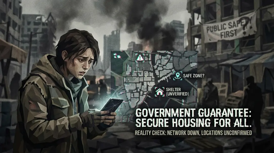
Recent revelations from a Radio ZET interview with the Deputy Head of the Ministry of Interior and Administration (MSWiA) exposed a stark reality: Poland’s official “shelters” can accommodate only a mere 4% of the country’s population. This figure stands in sharp contrast to the ministry’s published map, which astonishingly lists 76,731 so-called “shelter points.” However, a deeper investigation reveals a troubling truth: many of these locations are inaccessible, some don’t even exist, and the very term “shelter point” lacks a clear legal definition. The credibility of the system further eroded when one specific location was added to the map only after the author’s direct inquiry to the MSWiA spokesperson.

The Reality of Preparedness Amidst Global Unrest
For many, the idea of war directly impacting their lives seemed unthinkable just a few years ago. Yet, the ongoing conflict in Ukraine has dramatically shifted perspectives. A single decision can now transform a peaceful afternoon into a desperate search for safety from explosions. This grim reality underscores the urgent need for robust civilian protection, especially for a frontline nation like Poland. With the understanding that adversaries may disregard international conventions, civilian targets are as vulnerable as military ones—if not more so.
Evaluating the Government’s “Safety Guide” and Shelter Map
Many households are receiving a paper “Safety Guide,” also integrated into the mObywatel mobile application. While it offers practical advice, such as keeping power banks charged and physical maps handy for internet outages, its most critical feature—the “Where to Hide” shelter map—warrants closer inspection. Designed to guide citizens to the nearest safe havens in an emergency, the map sparked more questions than answers upon initial review. The critical question emerged: Is this map genuinely helpful, or does it inadvertently create a false sense of security?
Scenario 1: Navigating an Emergency in Unfamiliar Territory
The map’s utility is paramount when one is outdoors, in an unfamiliar area, and in immediate danger. To test its effectiveness, the author visited the Wola district of Warsaw, near Ciołka Street, a location typical of urban environments. The results were concerning.
- Despite thorough searching, the author could not access any of the locations marked as shelters on the map.
- Many “24/7 accessible” points, indicated by a green glow, were found to be private basements within apartment blocks, requiring keys for entry, or closed public facilities like libraries.
- In a situation where being in the open could be fatal, relying on this map would lead to dangerous, fruitless searching from building to building.
While acknowledging that some “shelters” are indeed basements—a reasonable inclusion for residents who might not realize their building offers protection—the inaccessibility from the outside renders the map useless for strangers in a crisis.
Scenario 2: Overlooking Existing, Robust Shelters
Ironically, while many listed shelters were inaccessible, many older residential buildings, particularly those from the 1950s, possess robust basement infrastructure that could serve as effective bomb shelters. These often include:
- Double, steel, and relatively airtight bulkheads.
- Some basement units even feature direct passages to designated shelter areas.
The author discovered that his family’s entire housing estate, with multiple blocks, each had such a basement. Yet, when checking the government map for this very estate, not a single shelter point was marked. This meant that residents, with potentially life-saving infrastructure directly beneath their homes, would be instructed by the ministry’s map to travel to a nearby supermarket parking lot—a perilous journey offering minimal protection compared to a purpose-built basement shelter.
Challenges with the Mobile Application and Shelter Definitions
The app itself presents several practical hurdles:
- Access in Gated Communities: In modern developments, many listed shelter locations are within gated communities, inaccessible to outsiders without prior knowledge or keycards. While an emergency might prompt desperate measures like jumping a barrier, finding the specific shelter within an unknown complex without clear guidance is a significant challenge.
- Lack of Detailed Navigation: The app fails to provide crucial details like specific entrances or photos, which are vital for quick evacuation under stress.
- Undefined Shelter Categories: The ministry’s own website distinguishes between “shelter,” “hideout,” and “temporary shelter point”—categories with significant differences in protection levels (e.g., against a storm versus a bombing raid). However, the app lumps all these into a single “shelter point” category, lacking essential information about the protection offered. This ambiguity could lead to disastrous choices in a crisis.
Ministry’s Response: Clarification or Continued Confusion?
Prompted by consistent findings from various public inquiries, including the author’s own, a formal request was sent to the MSWiA spokesperson, posing three key questions:
- What are the criteria for a room to be considered a shelter, and why are genuine shelters (like those in the author’s family building) not included?
- Is “shelter point” an umbrella term for shelters, hideouts, and temporary shelter points? If so, does the ministry plan to specify these categories for each location?
- Will the app be enhanced with additional information, such as directions or photos of entrances?
The MSWiA’s response highlighted several points:
- For an object to be recognized as a shelter, it must meet technical requirements set out in specific regulations (e.g., MSWiA regulations from February 21, 2025, and November 4, 2025, concerning criteria for protective structures). Crucially, it also requires official recognition by the relevant civil protection authority.
- The term “shelter” is often used colloquially for various protective structures. Legally, “shelter,” “hideout,” and “temporary shelter point” have distinct definitions in the Civil Protection and National Defense Act.
- “Shelter points” in the app are currently not statutorily defined but are part of a projected amendment to the law, aiming to establish them as the lowest category of protective infrastructure.
- The listed shelter points are based on criteria from relevant acts and a specific MSWiA regulation (July 9, 2025) concerning temporary shelter points.
- The map objectively reflects mapped points; it cannot account for individual users’ familiarity with the terrain.
- The ministry advises citizens to proactively identify their nearest shelter locations to avoid issues in a crisis.
- The app currently features “Route,” “Navigate,” and “Compass” options, with further expansion planned.
The Disconcerting Post-Inquiry Addition to the Map
The ministry’s explanation failed to clarify why the author’s family building, with its demonstrable shelter, was absent from the map. The requirement for official recognition, beyond technical compliance, was cited. However, a significant development occurred:
- The author’s family building, explicitly mentioned in his inquiry, was subsequently added to the ministry’s shelter map.
This raises critical questions:
- Did the location suddenly meet the necessary conditions, despite no physical changes?
- Or was it simply overlooked, and its existence verified only after the author’s direct contact?
The latter seems more plausible, especially since only this specific building was added to the map, while adjacent blocks with identical, known shelters remain unlisted. This suggests a reactive, rather than a systematic and comprehensive, verification process. Furthermore, it casts doubt on whether the “proper authority” genuinely verified the basement’s safety or if the addition was merely a response to an email, further eroding trust in the system’s operational integrity.
Conclusion: A Critical Failure in Public Safety Provision
The investigation reveals a troubling disconnect between the government’s efforts and the practical realities of public safety. The ambiguity surrounding “shelter points” (a term not yet legally defined but actively used) and the ministry’s advice to “familiarize oneself in advance” with local shelters in familiar areas fundamentally undermine the map’s purpose. Its sole crucial function—to guide individuals to safety in unfamiliar territory during a critical event—is clearly not being met. When “shelter points” are non-existent, inaccessible, or inaccurately listed, the entire system becomes a dangerous illusion, offering false hope instead of genuine assistance in a crisis.
Frequently Asked Questions (FAQ)
What is the official capacity of shelters in Poland?
According to the Deputy Head of the Ministry of Interior and Administration (MSWiA), existing shelters in Poland can accommodate only 4% of the country’s population.
What is a “shelter point” according to the Polish Ministry of Interior and Administration (MSWiA)?
Currently, “shelter point” is a colloquial term not yet formally defined in Polish law. The MSWiA is reportedly working on a legal amendment to establish “shelter points” as the lowest category of protective infrastructure. The government map lists these based on criteria for temporary shelter points, not necessarily full-fledged shelters.
Why are many listed “shelters” on the government map inaccessible or non-existent?
Investigations reveal that many listed “shelter points” are private basements requiring keys for entry, closed public buildings, or locations that do not physically exist. This appears to be due to a lack of thorough, systematic verification by authorities before inclusion on the map.
How should citizens prepare for an emergency given these issues with the shelter map?
The MSWiA advises citizens to proactively identify and familiarize themselves with the nearest shelter locations to their homes or workplaces in advance. Given the map’s current unreliability, personal reconnaissance and preparation are crucial.
Will the Polish government’s shelter map be improved in the future?
The MSWiA has stated that the application currently features “Route,” “Navigate,” and “Compass” options, with further expansion planned. However, the article highlights deep systemic issues beyond just app features, suggesting that legislative and verification improvements are also critically needed.