
Contents
Hundreds of Errors Detected in Sea-Level Studies: Coastal Threat Maps Worldwide Are Changing
A recent study has unveiled a critical flaw in hundreds of sea-level rise threat analyses: scientists consistently used an incorrect reference point, systematically underestimating how high water currently reaches along coastlines. This significant oversight implies that tens of millions more people than previously estimated could be at risk from rising sea levels, fundamentally altering global coastal threat maps.
The Flawed “Zero” in Sea-Level Research
For decades, most flood risk maps have relied on a seemingly straightforward assumption: sea level represents the “zero” point from which land elevation is measured and future inundation is simulated. However, this assumed “zero” is often a mathematical model (a geoid) or an averaged value that frequently does not align with the actual, local water level at a specific coastline. Local sea levels are dynamically influenced by factors such as gravity, ocean currents, and tides, which can cause significant deviations from a global average or model.
A Methodological Blind Spot Uncovered
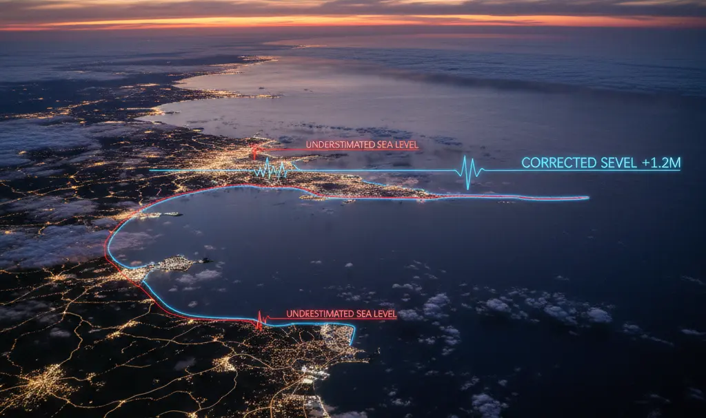
An extensive analysis of 385 peer-reviewed studies published between 2009 and 2025 revealed a startling truth: over 99% of these studies improperly linked land elevation data with sea level. Furthermore, approximately 90% failed to use local water level readings as a reference point at all. The authors of this landmark study, published in the prestigious journal Nature, describe this widespread issue as a “methodological blind spot.”
This problem stems from the fact that satellite-derived elevation data typically refer to a global gravitational model (geoid). In reality, the local sea level at any given location can deviate from this model by tens of centimeters, and in some cases, even close to two meters. This initial error creates a domino effect, leading all subsequent predictions and projections to be based on overly optimistic assumptions about future sea-level rise and its impacts.
Quantifying the Underestimated Sea Level and Risk
The research team calculated that previous studies systematically underestimated coastal water heights by an average of approximately 24–27 centimeters. In many regions, this underestimation alone accounts for an entire “century” of predicted sea-level rise. The implications are particularly severe in regions like Southeast Asia and the Pacific Islands, where corrected coastal elevations are proving to be up to a meter lower than indicated by commonly used surface topography models.
In contrast, Europe and the eastern coast of North America fared somewhat better. These regions benefit from denser networks of tide gauges and long-term observation stations, which have historically led to more frequent calibration between land elevation and local sea level, thereby reducing the margin of error.
How Scientists Are Correcting the Maps
When researchers rectified the “zero” reference point—by aligning land elevations with local water readings and adding approximately one meter to projected ocean level increases—the global picture of coastal exposure dramatically shifted. In this revised scenario, the land area situated below sea level increases by a substantial 31–37%, instead of the “insignificant” rise suggested by many earlier estimates.
“Our corrected calculations show that after a 1-meter relative rise […] 37 percent more land area and 68 percent more people—up to 132 million—will be below sea level than previous geoid-based assessments suggested.”
Katharina Seeger, University of Cologne
When these corrected terrain elevations are factored in, the number of people who would find themselves below sea level (given a one-meter rise) drastically surpasses previous global estimates:
The population residing in such vulnerable areas could range from 77–132 million, representing a 48–68% increase over previous analyses. This fundamental revision completely transforms the scale of the challenges faced by coastal nations worldwide.
Beyond critiquing outdated methods, the study’s authors have proactively made new elevation datasets publicly available. These datasets merge land elevation information with empirically measured local sea levels and mean dynamic ocean topography (MDT). This innovative approach offers a more accurate and reliable foundation for future coastal risk assessments and planning.
Frequently Asked Questions (FAQ)
What was the primary error found in previous sea-level rise studies?
Previous studies incorrectly set the “zero” reference point for sea level. They often used global mathematical models (geoids) or averaged values instead of actual, local sea levels, leading to a systematic underestimation of coastal water heights.
How significantly were sea levels underestimated?
On average, coastal water heights were underestimated by 24–27 centimeters. In some critical regions like Southeast Asia and the Pacific Islands, the underestimation reached up to a meter.
What are the implications of these corrected findings for coastal populations?
The corrected data indicates that after a one-meter sea-level rise, 31–37% more land area and 48–68% more people (potentially 77–132 million individuals) could be living below sea level than previously thought. This dramatically increases the scale of risk and challenges for coastal communities.
How are scientists addressing this issue?
Researchers are correcting maps by aligning land elevations with local water level readings and providing new datasets that combine land elevation with empirically measured local sea levels and mean dynamic ocean topography (MDT) for more accurate assessments.
Why are local sea level readings more accurate than global models?
Local sea levels are influenced by dynamic factors like gravity, ocean currents, and tides, causing them to deviate from global gravitational models (geoids) by significant amounts, sometimes up to two meters. Therefore, local measurements provide a more realistic baseline for assessing flood risk.
Source: Earth, Nature, NBC News, Science News, Smithsonian Magazine. Opening photo: Gemini