

Contents

Unveiling the Unknown: An Accidental Discovery in Antarctica
Even in the 21st century, Earth continues to hold undiscovered secrets. A recent, entirely accidental find by a team of German scientists proves exactly how much remains unknown about the most remote corners of our planet. While modern science often looks to the stars—even exploring how oxygen to be extracted on the Moon—there are still uncharted territories waiting to be found right here on our home planet.

An Unplanned Expedition Outcome
Information about this extraordinary find was recently highlighted by the French science magazine Science & Vie, which detailed the story of a German research expedition in Antarctica. Scientists from the Alfred Wegener Institute never anticipated that their routine mission would yield such a surprising result.
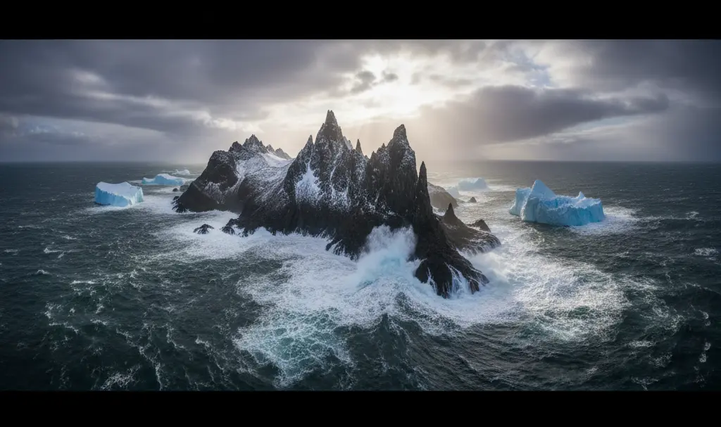
During a February research mission, the team was studying the dynamics of glaciers near the Larsen Ice Shelf. However, their research vessel, the Polarstern, was forced to abruptly change its course when a violent storm hit the region. Seeking safe harbor, the ship navigated toward Joinville Island, moving into an area traditionally marked on nautical charts as hazardous for navigation.
Advanced Tech Reveals a Hidden Landmass
It was precisely there, in a zone deemed risky for maritime travel, that the researchers noticed something completely unexpected. Instead of open, storm-churned water or pack ice, they encountered a small landmass that simply did not exist on any official map.
The scientific team quickly confirmed they had stumbled upon a previously unknown island. Utilizing advanced surveying equipment, including multibeam sonars and LiDAR (Light Detection and Ranging) technology, the crew meticulously measured the new geographic feature. The island’s dimensions are roughly:
- Length: 130 meters (approximately 426 feet)
- Width: 50 meters (approximately 164 feet)
- Elevation: Rising 16 meters (about 52 feet) above sea level
Despite its relatively small size, an uncharted landmass of this scale poses a highly severe threat to shipping vessels that rely on accurate nautical maps to safely navigate the treacherous Antarctic waters.
How Climate Change is Redrawing the World Map
This accidental discovery raises critical questions about the rapid environmental shifts occurring in polar regions. As the push for sustainable solutions drives the renewable energy revolution future global power, understanding the immediate, physical impacts of global warming is more crucial than ever. Over the past few years, climatologists have observed a significant reduction in the ice cover of the northwestern Weddell Sea. It is highly likely that this melting process finally granted access to an area that was previously impenetrable.
Was the Island Always There?
Experts do not rule out the possibility that the island has existed for millennia. However, it was almost certainly buried under massive glaciers or surrounded by sea ice so thick that no human vessel could ever reach it. At the same time, researchers suggest that local climate changes could be altering the shape of the seabed itself, actively exposing new terrain formations.
Official Recognition and Future Mapping
The newly discovered island will soon receive an official name and be integrated into international geographic databases, including the crucial bathymetric maps of the Southern Ocean. This event serves as a powerful reminder that our knowledge of Earth still has its limits, and every scientific expedition carries the potential for groundbreaking, unexpected discoveries.
Frequently Asked Questions (FAQ)
How does glacial retreat lead to the discovery of new islands?
As global temperatures rise, massive ice shelves and coastal glaciers melt and recede. This continuous melting process strips away thick layers of ice that have existed for thousands of years, eventually exposing the underlying bedrock and previously hidden landmasses to the open ocean.
Why do small uncharted islands pose a danger to ships?
Modern maritime navigation relies heavily on precise bathymetric and nautical charts. When a landmass is absent from these maps, ship captains are unaware of the collision risk. In regions like Antarctica, where storms and poor visibility are common, an unmapped rocky island can easily damage or sink a passing vessel seeking shelter.
What technologies do scientists use to map newly discovered landmasses?
Researchers primarily utilize multibeam sonar systems to map the underwater topography (bathymetry) and LiDAR (Light Detection and Ranging) lasers to scan the above-water terrain. Together, these tools create highly accurate, three-dimensional models of the new environment.
Source: Science & Vie, own elaboration. Opening photo: Gemini